NASA's Earth Observation Satellite "Aqua" carries four sensors in addition to AMSR-E, which was developed by JAXA. One is the Moderate Resolution Imaging Spectroradiometer (MODIS), which was developed by NASA Goddard Space Flight Center (GSFC). It is a 36-band spectroradiometer measuring visible and infrared radiation within the 0.4 to 14 µm band. The first MODIS instrument was launched on board the "Terra" satellite in December 1999.
| MODIS | AMSR-E |
 |
 |
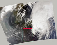
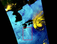
Figure 1 compares RGB composite images derived from MODIS (left) and AMSR-E (right) for Super Typhoon "HIGOS" (Typhoon No. 21) approaching Japan at 0421 (UTC) October 1, 2002. The typhoon moved northward at high speed and landed in Tokyo metropolitan area several hours after Aqua's observation. It caused enormous damage throughout the Kanto, Tohoku and Hokkaido areas in Japan.
The MODIS image is a RGB composite of radiance using 645, 555 and 470 nm wavelengths at 500 m resolution. The AMSR-E image shows brightness temperature using channels of 89-GHz vertical and horizontal polarization and 23.8-GHz vertical polarization. In the AMSR-E image, possible strong precipitation areas over the ocean are highlighted in bright yellow; colors varying from aqua to dark blue correspond to increases of water vapor and clouds. It can be seen that MODIS, the optical sensor, resolves the fine structure of clouds and surface, and that AMSR-E, the microwave imager, is not affected by clouds and can observe day and night. In other words, MODIS visualizes shapes of clouds, oceans and land like the human eye, and AMSR-E presents us shapes of water, which is hard to visualize in human eye, under various cloud and atmosphere conditions.
| MODIS | AMSR-E |
 |
 |
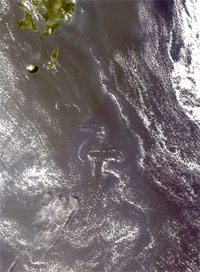
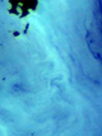
Figure 2 shows close-up views of red rectangles in Fig. 1. In close-up view of MODIS (left), the Kármán vortex street caused by Yaku-shima (Yaku Island) is clearly seen oriented northwest to southeast from island; it can also be seen in the AMSR-E close-up image (right). AMSR-E can capture such a detailed spatial structure, because it has one of the largest ever microwave radiometer antennas.
The MODIS data used here were acquired from Goddard Distributed Active Archive Center (DAAC). The data were processed by the MODIS Adaptive Processing System (MODAPS) and Goddard DAAC, and are archived and distributed by the Goddard DAAC.