Japan Aerospace Exploration Agency Earth Observation Research Center ALL RIGHTS RESERVED.

|
|
Recently, there has been an increasing demand for quantitatively evaluated satellite products.
Since AMSR/AMSR-E is expected to contribute to climate change research and its monitoring, the geophysical products should be stable in the long term.
To meet this requirement, the AMSR/AMSR-E calibration and validation project will evaluate brightness temperatures and geophysical parameters.

Calibration begins from pre-launch performance and calibration tests of the instrument and ends with the post-launch confirmation of designed performance in orbit.
Post-launch calibration activities include an analysis of AMSR/AMSR-E calibration and ancillary data, under-flight campaigns using the Airborne Microwave Radiometer (AMR), and inter-sensor comparison with similar space-borne instruments such as SSM/I.
Sensor characteristics will be monitored to assess the long-term quality of the AMSR/AMSR-E products.
AMSR/AMSR-E brightness temperatures will be examined by comparing them with those of similar sensors such as SSM/I and TRMM/TMI.
In addition to this direct comparison of brightness temperatures, inter-sensor comparisons with visible-infrared radiometers or radars are informative.
For example, comparisons with the Global Imager (GLI) on ADEOS-II or the Moderate Resolution Imaging Spectroradiometer (MODIS) on Aqua will provide finer spatial information of small -scale features such as snow cover and sea ice distribution.
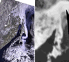
The figure compares an SSM/I 37GHz image and a two-band composite of the Advanced Very High Resolution Radiometer (AVHRR) for sea ice distributions in the Sea of Okhotsk in wintertime.
It can be seen that the AVHRR resolves the fine structure of the sea ice distribution while the SSM/I image is not affected by clouds.
In this manner, intercomparisons among the sensors with different characteristics supplement the information, increasing the reliability of each sensor.

Validation of AMSR/AMSR-E geophysical products is mainly based on comparing AMSR/AMSR-E estimates and actual measurements of geophysical parameters by in-situ or aircraft observations.
Operational in-situ data from every corner of the world are collected and compared with AMSR estimates.
Field campaigns are conducted in cooperation with world research programs such as WCRP/GEWEX, related agencies and universities, and the US AMSR-E science team.
In particular, AMSR/AMSR-E field campaigns are closely related with the GEWEX Coordinated Enhanced Observing Period (CEOP).
|
|
|
|
|
|
Cal/Val Plan(PDF: 91KB) AMR website |