Japan Aerospace Exploration Agency Earth Observation Research Center ALL RIGHTS RESERVED.

|
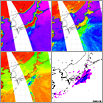
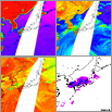
These images show AMSR-E data and Radar-AMeDAS (*) composite data obtained from observations around Japan at approximately the same time. Currently, the AMSR-E brightness temperature is being calibrated at JAXA EORC. Radar-AMeDAS composite data indicates hourly precipitation and is provided by the Japan Weather Association in real time.
* Radar-AMeDAS is a combined rainfall map for Japan obtained from JMA's automatic observation facility, called the Automated Meteorological Data Acquisition System (AMeDAS), and ground-based weather radar.
|