


About the GPM Quick Look
The GPM Quick Look is web page that shows browse images of standard data observed by the GPM Core Observatory, TRMM satellite, and GPM Global Rainfall Map (GSMaP) in layers of Google Maps.
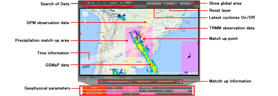
You can look at not only the latest images but also display the past images by search.
Definition of a term
| Latest image | To display the latest observation image by KuPR on board the GPM Core Observatory. |
|---|---|
| Latest cyclones | To display its storm track, position, and information of intensity, when the tropical cyclone (including typhoons, hurricanes, and cyclones) exists. Displaying area will change automatically to show position of the tropical cyclone. If the tropical cyclones exist in wider area, Google Maps show global area. |
| Reset layer | To reset the displaying layers all at once. |
| Match-up point | Match-up points are defined that differences in distance between observation points of the GPM Core Observatory and TRMM satellite are within radius 200 km, and differences in observation time of those are within 10 minutes. |
| Counts of match-up | Total count number of match-up point within a day. There is a day whose count number is zero. |
| Precipitation match-up area | If a match-up point is located within radius 10 degree from the center of precipitation areas of KuPR, we defined this area as "Precipitation match-up area." |
| Time information | Observation time of the satellite at nadir is indicated by markers. When clicking or overlaying mouse to the marker, it displays time information, satellite orbit number, and distance to the match-up point if it exists, |
Guidance of images
Usage
- Select date and time (UTC) to display and click submit button Note: You can also select "Daily" on top of the dropdown list to show all observation images within that day. You cannot select "Daily" for images in the GSMaP category.
- Select geophysical parameter(s) to display You can select multi parameters. Images will be overlaying in a sequential order of selection. Image to be displayed on top of layers should be selected at the last.
Trouble shooting
- If you select too much layers, performance may be slow. In this case, please reset layers displaying.
- Performance may be slow if you change date and/or time as displaying time information.
- If you changes date and/or time continuously before selected layers are displayed, non-selected information may be displayed and performance become slow. In this case, please reset layers displaying, and select the target date/time again.
- When you select the latest cyclone button, displaying area is automatically changed to show position of the tropical cyclone. Please note that if the multi tropical cyclones exist, Google Maps may show global area.
Terms of Use of images
Please refer to "Terms of Use of Research Data" (https://earth.jaxa.jp/policy/en.html) for the use of images.