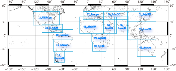
15 areas are defined for Text format as in following Figure.

| Area name | Longitude | Latitude | Description | ||
|---|---|---|---|---|---|
| West | East | South | North | ||
| 01_AsiaEE | 90 | 155 | 30 | 50 | East Asia |
| 02_AsiaSE | 90 | 155 | -10 | 30 | South East Asia |
| 03_Austra | 112 | 155 | -45 | -10 | Australia |
| 04_AsiaCC | 35 | 90 | 35 | 50 | Central Asia |
| 05_AsiaSS | 60 | 93 | 5 | 40 | South Asia |
| 06_AsiaSW | 35 | 65 | 4 | 40 | Arabian Peninsula and East Africa |
| 07_Europe | -11 | 35 | 35 | 50 | Europe |
| 08_AfriNW | -19 | 35 | 4 | 40 | North West and Central Africa |
| 09_AfriSN | 8.5 | 48 | -15 | 4 | Southern Africa (North) |
| 10_AfriSS | 10 | 41 | -35 | -15 | Southern Africa (South) |
| 11_USACon | -125 | -65 | 23 | 50 | USA (Contiguous) |
| 12_C_Amer | -105 | -58 | 7 | 25 | Central America |
| 13_SAmerN | -82 | -34 | -10 | 13 | South America (North) |
| 14_SAmerC | -79 | -34 | -35 | -10 | South America (Central) |
| 15_SAmerS | -77 | -54 | -56 | -35 | South America (South) |
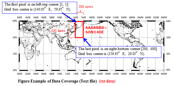
Each file is one of global coverage fractionated 54 areas and consists of 200 rows x 400 lines which is longitude-latitude elements corresponding to a 0.1 x 0.1 degree grid that covers each fractionated area.
This file is available to open using Microsoft Excel directory. The number of effective digits is zero pint two digits.
Figure 2 is example of data coverage for the case of AAABBBB = 60N140E.
