| |
|
|

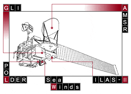
Outline of 5 sensors
AMSR
Advanced Microwave Scanning Radiometer | JAXA |  |
|
The Advanced Microwave Scanning Radiometer (AMSR) detects microwave emissions from the Earth's surface and atmosphere. Various geophysical parameters, particularly those related to water (H2O), can be estimated from AMSR data. In addition to the proven parameters, such as water vapor, precipitation, and sea surface wind speed, novel geophysical parameters, including sea surface temperature and soil moisture, are expected to be retrieved by using new frequency channels.
AMSR is an eight-frequency, total-power microwave radiometer with dual polarization (except two vertical channels in the 50GHz band). Conical scanning is employed to observe the Earth's surface with a constant incidence angle. Calibration counts are obtained every scan by using the hot load target (around 300K) and the cold-sky mirror to introduce the temperature of deep space (around 3K). The offset-parabolic antenna with a diameter of 2m is the largest space-borne microwave radiometer antenna of its kind. A superior spatial resolution enables us not only to resolve small-scale features, including clouds, precipitation, sea ice, and land, but also to improve retrieval accuracy of geophysical parameters.
|
| |  Top Top |
GLI
Global Imager |
JAXA |  |
GLI is an optical sensor that observes the reflected solar radiation from the Earth's surface, including land, oceans and clouds and/or infrared radiation with a multi-channel system for measuring the biological content, such as chlorophyll, organic substance, and vegetation index as well as temperature, snow and ice, and cloud distribution. These data will be used for understanding the global circulation of carbon and climate changes.
|
| | Top |
ILAS-II
Improved Limb Atmospheric Spectrometer-II |
MOE |  |
|
The Improved Limb Atmospheric Spectrometer-II (ILAS-II) was developed by the Ministry of the Environment to monitor the high-latitude stratospheric ozone. The objectives of ILAS-II are to monitor and study changes in the stratosphere triggered by emissions of chlorofluorocarbons (CFC), and to evaluate the effectiveness of world-wide emission controls of CFCs. ILAS-II is a spectrometer that observes the atmospheric limb absorption spectrum from the upper troposphere to the stratosphere using sunlight as a light source (solar occultation technique). The spectrometer covers the infrared region (3-13 micrometers) and the near visible region (753 to 784nm). ILAS-II was designed to improve observation accuracy and cover wider spectral ranges than ILAS, which was based on LAS aboard EXOS-C (Ohzora, ISAS, 1984). ILAS-II observation is intended to the high latitude (N57-73degree, S64-90degree) regions because of the geometrical relation of the solar occultation events with the sun synchronous orbit. From these spectral observations, ILAS-II can measure the vertical profiles of species related to ozone depletion phenomena, including ozone (O3), nitrogen dioxide (NO2), nitric acid (HNO3), aerosols, water vapor (H2O), CFC-11, CFC-12, methane (CH4), nitrous oxide (N2O), chlorine nitrate (ClONO2), and temperature and pressure.
|
| | Top |
| SeaWinds |
NASA/JPL |  |
NASA's SeaWinds Scatterometer will provide high accuracy wind speed and direction measurements over at least 90% of the ice-free global oceans every 2 days. SeaWinds will provide a continuing set of long term wind data for studies of ocean circulation, climate, air-sea interaction and weather forecasting. SeaWinds is a follow on to the NASA Scatterometer (NSCAT) on ADEOS and will, like NSCAT, provides measurements of ocean surface winds in all weather and cloud conditions.
The SeaWinds will use a one meter diameter dish antenna with two beams rotated about the satellite nadir axis at 18 RPM. SeaWinds radiates and receives microwave pulses at a frequency of 13.4 GHz across an 1800km wide swath.
Scatterometers use a highly indirect technique to measure wind velocity over the ocean. Changes in the wind velocity cause changes in ocean surface roughness, modifying the radar cross section of the ocean and the magnitude of the backscattered power. Multiple collocated measurements acquired from several directions can be used to determine wind speed and direction simultaneously.
|
| | Top |
POLDER
Polarization and Directionality of the Earth's Reflectances |
CNES |  |
The Polarization and Directionality of the Earth's Reflectances (POLDER) instrument will observe the polarization, directional and spectral characteristics of the solar light reflected by aerosols, clouds, oceans and land surfaces.
POLDER is a two-dimensional CCD array, with a wide field of view, multi band imaging radiometer and polarimeter developed by CNES. Multi-angle viewing is achieved by the along track migration, at the spacecraft velocity, of a quasi square footprint intercepted by the total instantaneous ±43° × ±51° wide field of view. This footprint is partitioned into 242 × 274 elements of quasi constant 7km × 6km resolution, imaged by a CCD matrix in the focal plane. Simultaneously, a filter and polarizer wheel rotate and scan eight narrow spectral bands in the visible and near infrared (443, 490, 564, 670, 763, 765, 865, 910 nm), and three polarization angles at 443, 670 and 865 nm.
|
| | Top |
|
|