
| INTRODUCTION | |
| Products | Code | Swath Subset | Daily/Polar Region | Daily/Specific Region |
|---|---|---|---|---|
| 6 GHz vertical polarization brightness temperature | 6GHz V-pol | üø | üø | üø |
| 37 GHz vertical polarization brightness temperature | 37GHz V-pol | üø | üø | üø |
| 89 GHz vertical polarization brightness temperature | 89GHz V-pol | üø | üø | üø |
| Sea Ice Concentration | ICO | ü~ | üø | üø |
| Soil Moisture | SMO | ü~ | ü~ | ü~ |
| Snow Water Equivalent | SWE | ü~ | ü~ | ü~ |
| SWATH SUBSET | |
On this page, you can browse subset images of individual paths of AMSR and AMSR-E.
Page usage and selectable parameters are described bellow.
1.Sensor
Select AMSR or AMSR-E by radio button.
2.Date
Select the observation date from the pull-down menu. The default is the date of the latest browse data.
3.Ascending/Descending
Select ascending orbit or descending orbit
4.Path Number(See " Definition of path number .")
Select path number . There are two ways of selecting the path number.One is to use a pull-down menu; the other is to use a clickable map.
|
To use map
(1)Click "Path map is here". (2)Click the target region of the map. The selected path number and latitude range appear, and the corresponding browse image is displayed after click "SUBMIT" button. 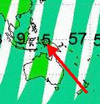
|
|
| DAILY / POLAR REGION | |
1.Sensor
Select AMSR or AMSR-E by radio button.
2.Date
Select the observation date from the pull-down menu. The default is the date of the latest browse data.
3.Brightness Temp
Select channels of brightness temperature from the pull-down menu. You cannot select Brightness Temperature and Geophysical Product at the same time.
4.Geophysical Product
Select the geophysical product from the pull-down menu. The code is explained at the bottom of each page. You cannot select Geophysical Product and Brightness Temperature (or Temperature Scale) at the same time.
5.Temp.Scale
"Temp.Scale" is fixed 145 - 310 (K) . Temperature scale is displayed in the right side of image .
6.Thumbnail image
The thumbnail image corresponding to the specified condition is displayed. The format of the image is jpeg. You can move to images for t
he previous or next day by clicking ![]() ,
,![]() .
.
7.Detailed image window
The browse image corresponding to the specified condition is displayed. The format of the image is jpeg with 288 dpi resolution. You can move to images for the previous or next day by clicking by clicking ![]() ,
,![]() . The message "file not found" is displayed when the specified image does not exist.
. The message "file not found" is displayed when the specified image does not exist.
8.Code Format
Three characters are provided for each part of the code; , and algorithm version. The codes of available geophysical products are tabulated.
| DAILY / SPECIFIC REGION | |
1.Sensor
Select AMSR or AMSR-E by radio button.
2.Date
Select the observation date from the pull-down menu. The default is the date of the latest browse data.
3.Brightness Temp
Select channels of brightness temperature from the pull-down menu. You cannot select Brightness Temperature and Geophysical Product at the same time.
4.Geophysical Product
Select the geophysical product from the pull-down menu. The code is explained at the bottom of each page. You cannot select Geophysical Product and Brightness Temperature (or Temperature Scale) at the same time.
5.Temp.Scale
Select the temperature scale for displaying brightness temperature from the pull-down menu. You can choose the appropriate temperature range from four scales, whole range (145-310 [K]), low range (150-205 [K]), middle range (200-255 [K]) and high range (250-305 [K]).
A color bar is displayed at the right side of the browse image.
6.Thumbnail image
The thumbnail image corresponding to the specified condition is displayed. The format of the image is jpeg. You can move to images for t
he previous or next day by clicking ![]() ,
,![]() .
.
7.Detailed image window
The browse image corresponding to the specified condition is displayed. The format of the image is jpeg with 144 dpi resolution. You can move to images for the previous or next day by clicking by clicking ![]() ,
,![]() . The message "file not found" is displayed when the specified image does not exist.
. The message "file not found" is displayed when the specified image does not exist.
8.Code Format
Three characters are provided for each part of the code; , and algorithm version. The codes of available geophysical products are tabulated.