 Feb. 27, 2003
Sea ice observation in the Sea of Okhotsk
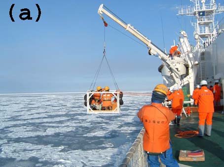
Sea-ice observations were performed in the Sea of Okhotsk for 10 days (February 5 to 14, 2003 ) to validate the accuracy of estimation in the analyzed images of
AMSR,
AMSR-E and
GLI. During the observations, the ice thickness and the snow depth were measured, and an ice core was obtained from a gondola without risky operations on the floating ice as shown in
(a). The distribution of the sea ice and the open water was observed from the upper deck of an icebreaker as shown in
(b). These data were used to validate the accuracy of sea-ice concentration derived from satellite data. Observations were also conducted from an aircraft to obtain data of the distribution and concentration of floating ice over a wider area for comparison with the satellite data because the ship data is limited to a small area.
On February 7, simultaneous observations were successfully conducted by satellite-onboard sensors,
AMSR,
AMSR-E and
GLI, and by the aircraft and the ship, and by the measurement on the floating ice panel. Image
(c) shows the sea ice concentration map prepared from
AMSR-E data for all of Okhotsk panel. Image
(d) shows the snow cover map and cloud map in Hokkaido and the sea-ice distribution in the southern part of the Sea of Okhotsk, as estimated from the
GLI data. Simultaneous observations are important for validating and improving the accuracy of satellite data for acquiring more reliable sea-ice parameters. In addition, these observations clarified the sea-ice thickness and the snow depth on the sea ice, which are currently difficult to estimate from satellite data.
» See Larger Images
-
Image (c): (400×550pixels: 47KB)
-
Image (d): (470×588pixels: 77KB)

We can obtain various information, such as the extent and the concentration of sea ice and the distribution of snow coverage, from these satellite data that are acquired every day. This satellite information is expected to clarify the Earth's climate system and to be useful for resolving the climate change issues such as extraordinary weather and global warming. Furthermore, the calibration and validation plans are to be implemented by ships and aircraft as well as detailed observations on the ground.
- * The estimated accuracy of the image on this page is a tentative value produced during the current verification work.
- * Observation cooperation: Chiba University Center for Environmental Remote Sensing, Hokkaido University, Tokai University, Kitami Institute of Technology, National Maritime Research Institute, 1st Regional Coast Guard Headquarters, patrol vessel "SOYA"
Earth Observation Research and application Center, Japan Aerospace Exploration Agency
JAXA EORC
ALL RIGHTS RESERVED.