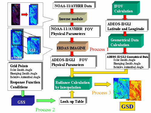
Process of Making GSD


  1. Process 1 : Making 2-D physical parameters to simulate GLI Observation
  2. Process 2 : Making Look-up table of radiance by using GSS
    2.1 Grid points
    2.2 Conditions
  3. Process 3 : Obtaining radiance data of each pixel by interpolation


  1. Process 1 : Making 2-D physical parameters to simulate GLI Observation
  2. GLI Level-1B data has 1276 * 1680 pixels. In order to simulate GLI Observation, each pixel would need the following:
    To obtain them, the following steps were taken.
    1. Obtaining large enough 2-D Physical Parameters to cover ADEOS-II/GLI field of view(FOV).
      FOV
      Satellite/SensorFOV
      NOAA-11/AVHRR~2000km
      ADEOS-II/GLI~1600km

      This set of data includes Longitude/Latitude and Physical Parameters of NOAA-11/AVHRR.
    2. Calculating longitude and latitude which GLI would observe by using "IFOV Calculation program".
    3. Calculating geometrical Data(ADEOS-II/GLI): Solar Zenith Angle, Emerging Zenith Angle and Relative Azimuthal Angle by using "Geometrical Data Calculation Program".
    4. Transforming field of view with ERDAS IMAGINE.(Resampling):
      • NOAA-11/AVHRR Physical Parameters --->ADEOS-II/GLI Physical Parameters
      • The ground resolution at nadir of NOAA-11/AVHRR GAC data is 4[km]. The ground resolution at nadir of GLI is 1[km].
      • The resampling method is nearest neighbor.
    Back to TOP

  3. Process 2 : Making Look-up table of radiance by using GSS
  4. 2.1 Grid points

    Look-up table of radiance are calculated on grid by using GSS.

    Grid Points
    Item Grid Point
    Solar Zenith Angle[deg]20.0, 30.0, 35.0, 40.0, 45.0, 50.0
    Emerging Zenith Angle[deg] 0.0, 5.0, 10.0, 20.0, 30.0, 35.0, 40.0, 45.0, 50.0, 55.0
    Relative Azimuthal Angle[deg]0.0, 10.0, 20.0, 30.0, 40.0, 50.0, 60.0, 70.0, 80.0, 90.0, 100.0, 110.0, 120.0, 130.0, 140.0, 150.0, 160.0, 170.0, 180.0
    Cloud Height[km]1.0, 2.0, 3.0, 4.0
    Cloud Optical Thickness1.0, 2.0, 4.0, 6.0, 9.0, 14.0, 20.0, 30.0, 50.0, 70.0
    Cloud Effective Radius[µm]4.0, 6.0, 9.0, 12.0, 15.0, 20.0, 25.0, 30.0

    2.2 Conditions

    GSS solves the radiative transfer equation. It can set sensor response function, atmospheric status and boundary surface.

    Conditions
    Sensor response function Engineering Model.
    Atmospheric modelUS standard model
    Number of sublayers to define the atmosphere13Interface number to define sublayers to construct the atmosphere50,21,16,11,10,9,8,7,6,5,4,3,2,1
    Boundary surface in the bottomOceanwind velocity at 10[m] above ocean5[m/sec]
    Aerosol typeH2Oaerosol size distributionLog-normal
    Back to TOP

  5. Process 3 : Obtaining radiance data of each pixel by interpolation
  6. Radiance of each pixel (for 1276*1680 pixels) are calculated using Look-up Table made in Process_2 and bilinear interpolation.
    Physical Parameters and Geometrical Data(ADEOS-II/GLI FOV) are input to "Interpolation program", which refers to Look-up table and outputs interpolated radiance for all pixels.
    Back to TOP