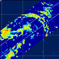
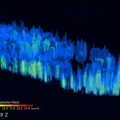
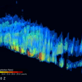
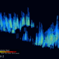
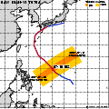
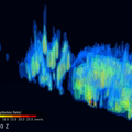
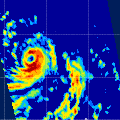
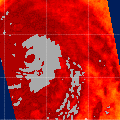
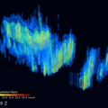
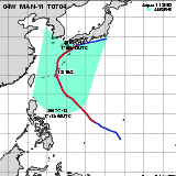
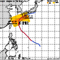
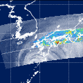
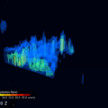
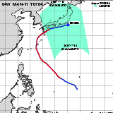
| Observation Area | PR 3D | KuPR/PR/VIRS
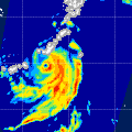
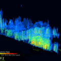
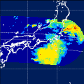
Image | AMSR-E/AMSR
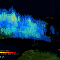
Precipitation | AMSR-E/AMSR
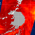
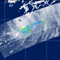
Total Precipitable Water | Information | GSMaP |
|---|
 |  |  |  onClick='toggleDiv(event,this.src,"imageA");' onClick='toggleDiv(event,this.src,"imageA");' |  |
|
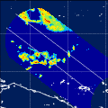
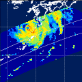
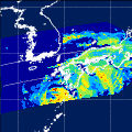
GSMaP |
 |  |  |  onClick='toggleDiv(event,this.src,"imageA");' onClick='toggleDiv(event,this.src,"imageA");' | |
|
GSMaP |
 |  |  |  onClick='toggleDiv(event,this.src,"imageA");' onClick='toggleDiv(event,this.src,"imageA");' | |
|
GSMaP |
 |  |  |  onClick='toggleDiv(event,this.src,"imageA");' onClick='toggleDiv(event,this.src,"imageA");' | |
|
GSMaP |
 | | |  |  |
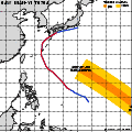
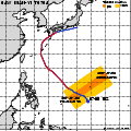
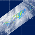
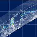
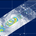
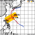
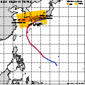
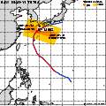
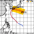
| Date/Time: | Jul 09,2007 04:26 (UTC) |
| Satellite/Sensor: | Aqua/AMSR-E |
| Path Number | 212MA |
| Lat/Lon: | 0.0N-19.4N
126.4E-143.5E |
| DownLoad: | P01B(V05) P2AP0(V05) P2WV0(V05) |
|
GSMaP |
 |  |  |  onClick='toggleDiv(event,this.src,"imageA");' onClick='toggleDiv(event,this.src,"imageA");' | |
|
GSMaP |
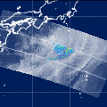
 | | |  |  |
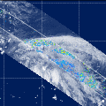
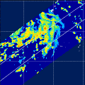
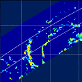
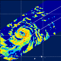
| Date/Time: | Jul 09,2007 16:41 (UTC) |
| Satellite/Sensor: | Aqua/AMSR-E |
| Path Number | 107MD |
| Lat/Lon: | 4.8N-24.3N
126.6E-144.0E |
| DownLoad: | P01B(V05) P2AP0(V05) P2WV0(V05) |
|
GSMaP |
 |  |  |  onClick='toggleDiv(event,this.src,"imageA");' onClick='toggleDiv(event,this.src,"imageA");' | |
|
GSMaP |
 |  |  |  onClick='toggleDiv(event,this.src,"imageA");' onClick='toggleDiv(event,this.src,"imageA");' | |
|
GSMaP |
 |  |  |  onClick='toggleDiv(event,this.src,"imageA");' onClick='toggleDiv(event,this.src,"imageA");' | |
|
GSMaP |
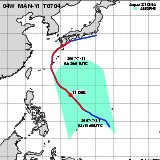 | | |  |  |
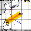
| Date/Time: | Jul 11,2007 04:15 (UTC) |
| Satellite/Sensor: | Aqua/AMSR-E |
| Path Number | 210MA |
| Lat/Lon: | 4.8N-24.2N
128.1E-145.6E |
| DownLoad: | P01B(V05) P2AP0(V05) P2WV0(V05) |
|
GSMaP |
 |  |  |  onClick='toggleDiv(event,this.src,"imageA");' onClick='toggleDiv(event,this.src,"imageA");' | |
|
GSMaP |
 | | |  |  |
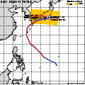
| Date/Time: | Jul 12,2007 04:59 (UTC) |
| Satellite/Sensor: | Aqua/AMSR-E |
| Path Number | 217MA |
| Lat/Lon: | 8.8N-28.3N
116.1E-134.0E |
| DownLoad: | P01B(V05) P2AP0(V05) P2WV0(V05) |
|
GSMaP |
 | | |  |  |
| Date/Time: | Jul 12,2007 17:08 (UTC) |
| Satellite/Sensor: | Aqua/AMSR-E |
| Path Number | 112MD |
| Lat/Lon: | 17.9N-37.5N
121.5E-140.7E |
| DownLoad: | P01B(V05) P2AP0(V05) P2WV0(V05) |
|
GSMaP |
 |  |  |  onClick='toggleDiv(event,this.src,"imageA");' onClick='toggleDiv(event,this.src,"imageA");' | |
|
GSMaP |
 |  |  |  onClick='toggleDiv(event,this.src,"imageA");' onClick='toggleDiv(event,this.src,"imageA");' | |
|
GSMaP |
 |  |  |  onClick='toggleDiv(event,this.src,"imageA");' onClick='toggleDiv(event,this.src,"imageA");' | |
|
GSMaP |
 |  |  |  onClick='toggleDiv(event,this.src,"imageA");' onClick='toggleDiv(event,this.src,"imageA");' | |
|
GSMaP |
 |  |  |  onClick='toggleDiv(event,this.src,"imageA");' onClick='toggleDiv(event,this.src,"imageA");' | |
|
GSMaP |
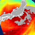
 | | |  |  |
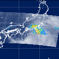
| Date/Time: | Jul 14,2007 04:49 (UTC) |
| Satellite/Sensor: | Aqua/AMSR-E |
| Path Number | 215MA |
| Lat/Lon: | 18.4N-38.0N
115.8E-135.2E |
| DownLoad: | P01B(V05) P2AP0(V05) P2WV0(V05) |
|
GSMaP |
 | | |  |  |
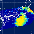
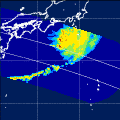
| Date/Time: | Jul 14,2007 16:53 (UTC) |
| Satellite/Sensor: | Aqua/AMSR-E |
| Path Number | 110MD |
| Lat/Lon: | 26.8N-46.4N
126.2E-147.7E |
| DownLoad: | P01B(V05) P2AP0(V05) P2WV0(V05) |
|
GSMaP |
 |  |  |  onClick='toggleDiv(event,this.src,"imageA");' onClick='toggleDiv(event,this.src,"imageA");' | |
|
GSMaP |
 |  |  |  onClick='toggleDiv(event,this.src,"imageA");' onClick='toggleDiv(event,this.src,"imageA");' | |
|
GSMaP |
 |  |  |  onClick='toggleDiv(event,this.src,"imageA");' onClick='toggleDiv(event,this.src,"imageA");' | |
|
GSMaP |
 | | | 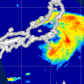 |  |
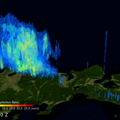
| Date/Time: | Jul 15,2007 03:54 (UTC) |
| Satellite/Sensor: | Aqua/AMSR-E |
| Path Number | 206MA |
| Lat/Lon: | 20.4N-40.0N
128.9E-148.7E |
| DownLoad: | P01B(V05) P2AP0(V05) P2WV0(V05) |
|
GSMaP |