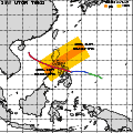
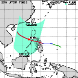
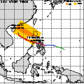
| Observation Area | PR 3D | KuPR/PR/VIRS
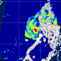
Image | AMSR-E/AMSR
Precipitation | AMSR-E/AMSR
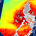
Total Precipitable Water | Information | GSMaP |
|---|
 |  |  |  onClick='toggleDiv(event,this.src,"imageA");' onClick='toggleDiv(event,this.src,"imageA");' |  |
|
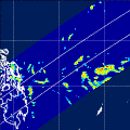
GSMaP |
 |  |  |  onClick='toggleDiv(event,this.src,"imageA");' onClick='toggleDiv(event,this.src,"imageA");' | |
|
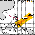
GSMaP |
 |  |  |  onClick='toggleDiv(event,this.src,"imageA");' onClick='toggleDiv(event,this.src,"imageA");' | |
|
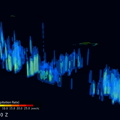
GSMaP |
 | | |  |  |
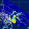
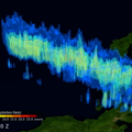
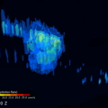
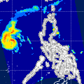
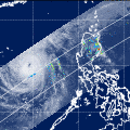
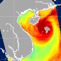
| Date/Time: | Dec 09,2006 04:50 (UTC) |
| Satellite/Sensor: | Aqua/AMSR-E |
| Path Number | 216MA |
| Lat/Lon: | 1.0S-18.4N
120.4E-137.5E |
| DownLoad: | P01B(V04) P2AP0(V04) P2WV0(V04) |
|
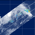
GSMaP |
 |  |  |  onClick='toggleDiv(event,this.src,"imageA");' onClick='toggleDiv(event,this.src,"imageA");' | |
|
GSMaP |
 | | |  |  |
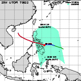
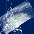
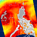
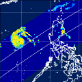
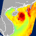
| Date/Time: | Dec 09,2006 17:06 (UTC) |
| Satellite/Sensor: | Aqua/AMSR-E |
| Path Number | 111MD |
| Lat/Lon: | 3.3N-22.7N
120.0E-137.3E |
| DownLoad: | P01B(V04) P2AP0(V04) P2WV0(V04) |
|
GSMaP |
 | | |  |  |
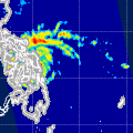
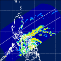
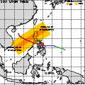
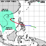
| Date/Time: | Dec 10,2006 05:34 (UTC) |
| Satellite/Sensor: | Aqua/AMSR-E |
| Path Number | 223MA |
| Lat/Lon: | 0.8S-18.6N
109.6E-126.6E |
| DownLoad: | P01B(V04) P2AP0(V04) P2WV0(V04) |
|
GSMaP |
 |  |  |  onClick='toggleDiv(event,this.src,"imageA");' onClick='toggleDiv(event,this.src,"imageA");' | |
|
GSMaP |
 |  |  |  onClick='toggleDiv(event,this.src,"imageA");' onClick='toggleDiv(event,this.src,"imageA");' | |
|
GSMaP |
 | | |  |  |
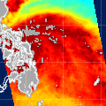
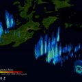
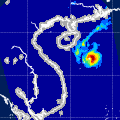
| Date/Time: | Dec 10,2006 17:48 (UTC) |
| Satellite/Sensor: | Aqua/AMSR-E |
| Path Number | 118MD |
| Lat/Lon: | 7.2N-26.6N
110.0E-127.7E |
| DownLoad: | P01B(V04) P2AP0(V04) P2WV0(V04) |
|
GSMaP |
 |  |  |  onClick='toggleDiv(event,this.src,"imageA");' onClick='toggleDiv(event,this.src,"imageA");' | |
|
GSMaP |
 | | |  |  |
| Date/Time: | Dec 12,2006 05:23 (UTC) |
| Satellite/Sensor: | Aqua/AMSR-E |
| Path Number | 221MA |
| Lat/Lon: | 4.0N-23.5N
111.3E-128.7E |
| DownLoad: | P01B(V04) P2AP0(V04) P2WV0(V04) |
|
GSMaP |
 |  |  |  onClick='toggleDiv(event,this.src,"imageA");' onClick='toggleDiv(event,this.src,"imageA");' | |
|
GSMaP |
 | | |  |  |
| Date/Time: | Dec 13,2006 06:06 (UTC) |
| Satellite/Sensor: | Aqua/AMSR-E |
| Path Number | 228MA |
| Lat/Lon: | 3.5N-22.9N
100.7E-118.0E |
| DownLoad: | P01B(V04) P2AP0(V04) P2WV0(V04) |
|
GSMaP |
 | | |  |  |
| Date/Time: | Dec 13,2006 18:18 (UTC) |
| Satellite/Sensor: | Aqua/AMSR-E |
| Path Number | 123MD |
| Lat/Lon: | 11.4N-30.8N
103.1E-121.3E |
| DownLoad: | P01B(V04) P2AP0(V04) P2WV0(V04) |
|
GSMaP |