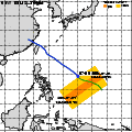
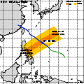
| Observation Area | PR 3D | KuPR/PR/VIRS
Image | AMSR-E/AMSR
Precipitation | AMSR-E/AMSR
Total Precipitable Water | Information | GSMaP |
|---|
 |  |  |  onClick='toggleDiv(event,this.src,"imageA");' onClick='toggleDiv(event,this.src,"imageA");' |  |
|
GSMaP |
 |  |  |  onClick='toggleDiv(event,this.src,"imageA");' onClick='toggleDiv(event,this.src,"imageA");' | |
|
GSMaP |
 |  |  |  onClick='toggleDiv(event,this.src,"imageA");' onClick='toggleDiv(event,this.src,"imageA");' | |
|
GSMaP |
 |  |  |  onClick='toggleDiv(event,this.src,"imageA");' onClick='toggleDiv(event,this.src,"imageA");' | |
|
GSMaP |
 |  |  |  onClick='toggleDiv(event,this.src,"imageA");' onClick='toggleDiv(event,this.src,"imageA");' | |
|
GSMaP |
 |  |  |  onClick='toggleDiv(event,this.src,"imageA");' onClick='toggleDiv(event,this.src,"imageA");' | |
|
GSMaP |
 |  |  |  onClick='toggleDiv(event,this.src,"imageA");' onClick='toggleDiv(event,this.src,"imageA");' | |
|
GSMaP |
 |  |  |  onClick='toggleDiv(event,this.src,"imageA");' onClick='toggleDiv(event,this.src,"imageA");' | |
|
GSMaP |
 | | |  |  |
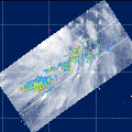
| Date/Time: | Jul 11,2006 04:45 (UTC) |
| Satellite/Sensor: | Aqua/AMSR-E |
| Path Number | 215MA |
| Lat/Lon: | 5.0N-24.5N
120.3E-137.8E |
| DownLoad: | P01B(V04) P2AP0(V04) P2WV0(V04) |
|
GSMaP |
 |  |  |  onClick='toggleDiv(event,this.src,"imageA");' onClick='toggleDiv(event,this.src,"imageA");' | |
|
GSMaP |
 | | |  |  |
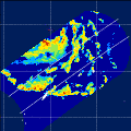
| Date/Time: | Jul 11,2006 16:56 (UTC) |
| Satellite/Sensor: | Aqua/AMSR-E |
| Path Number | 110MD |
| Lat/Lon: | 12.2N-31.7N
123.4E-141.7E |
| DownLoad: | P01B(V04) P2AP0(V04) P2WV0(V04) |
|
GSMaP |
 |  |  |  onClick='toggleDiv(event,this.src,"imageA");' onClick='toggleDiv(event,this.src,"imageA");' | |
|
GSMaP |
 |  |  |  onClick='toggleDiv(event,this.src,"imageA");' onClick='toggleDiv(event,this.src,"imageA");' | |
|
GSMaP |
 | | |  |  |
| Date/Time: | Jul 12,2006 17:39 (UTC) |
| Satellite/Sensor: | Aqua/AMSR-E |
| Path Number | 117MD |
| Lat/Lon: | 16.0N-35.5N
113.3E-132.2E |
| DownLoad: | P01B(V04) P2AP0(V04) P2WV0(V04) |
|
GSMaP |
 | | |  |  |
| Date/Time: | Jul 13,2006 04:35 (UTC) |
| Satellite/Sensor: | Aqua/AMSR-E |
| Path Number | 213MA |
| Lat/Lon: | 14.8N-34.3N
120.2E-138.9E |
| DownLoad: | P01B(V04) P2AP0(V04) P2WV0(V04) |
|
GSMaP |
 |  |  |  onClick='toggleDiv(event,this.src,"imageA");' onClick='toggleDiv(event,this.src,"imageA");' | |
|
GSMaP |
 |  |  |  onClick='toggleDiv(event,this.src,"imageA");' onClick='toggleDiv(event,this.src,"imageA");' | |
|
GSMaP |