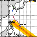
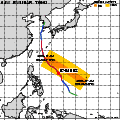
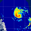
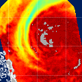
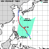
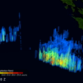
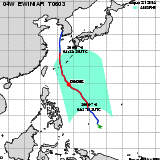
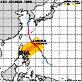
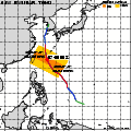
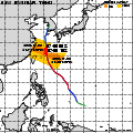
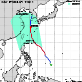
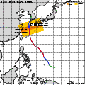
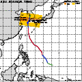
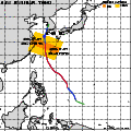
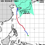
| Observation Area | PR 3D | KuPR/PR/VIRS
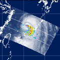
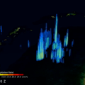
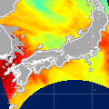
Image | AMSR-E/AMSR
Precipitation | AMSR-E/AMSR
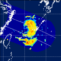
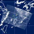
Total Precipitable Water | Information | GSMaP |
|---|
 |  |  |  onClick='toggleDiv(event,this.src,"imageA");' onClick='toggleDiv(event,this.src,"imageA");' |  |
|
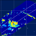
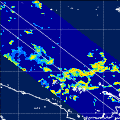
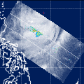
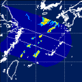
GSMaP |
 |  |  |  onClick='toggleDiv(event,this.src,"imageA");' onClick='toggleDiv(event,this.src,"imageA");' | |
|
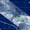
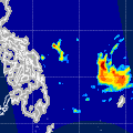
GSMaP |
 |  |  |  onClick='toggleDiv(event,this.src,"imageA");' onClick='toggleDiv(event,this.src,"imageA");' | |
|
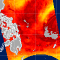
GSMaP |
 | | |  |  |
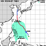
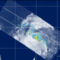
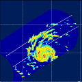
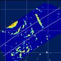
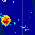
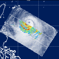
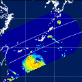
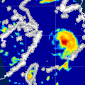
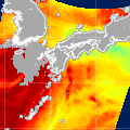
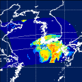
| Date/Time: | Jul 01,2006 04:05 (UTC) |
| Satellite/Sensor: | Aqua/AMSR-E |
| Path Number | 209MA |
| Lat/Lon: | 3.5S-15.9N
131.9E-148.9E |
| DownLoad: | P01B(V04) P2AP0(V04) P2WV0(V04) |
|
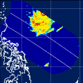
GSMaP |
 | | |  |  |
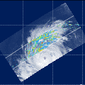
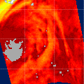
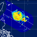
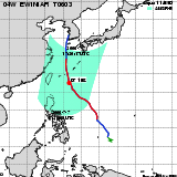
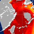
| Date/Time: | Jul 01,2006 16:21 (UTC) |
| Satellite/Sensor: | Aqua/AMSR-E |
| Path Number | 104MD |
| Lat/Lon: | 3.6N-23.0N
131.0E-148.3E |
| DownLoad: | P01B(V04) P2AP0(V04) P2WV0(V04) |
|
GSMaP |
 |  |  |  onClick='toggleDiv(event,this.src,"imageA");' onClick='toggleDiv(event,this.src,"imageA");' | |
|
GSMaP |
 |  |  |  onClick='toggleDiv(event,this.src,"imageA");' onClick='toggleDiv(event,this.src,"imageA");' | |
|
GSMaP |
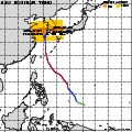
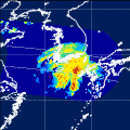
 | | |  |  |
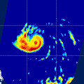
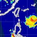
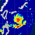
| Date/Time: | Jul 02,2006 04:50 (UTC) |
| Satellite/Sensor: | Aqua/AMSR-E |
| Path Number | 216MA |
| Lat/Lon: | 0.6N-20.0N
120.0E-137.2E |
| DownLoad: | P01B(V04) P2AP0(V04) P2WV0(V04) |
|
GSMaP |
 | | |  |  |
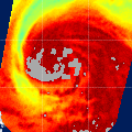
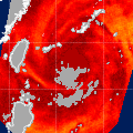
| Date/Time: | Jul 02,2006 17:05 (UTC) |
| Satellite/Sensor: | Aqua/AMSR-E |
| Path Number | 111MD |
| Lat/Lon: | 4.1N-23.5N
120.2E-137.7E |
| DownLoad: | P01B(V04) P2AP0(V04) P2WV0(V04) |
|
GSMaP |
 |  |  |  onClick='toggleDiv(event,this.src,"imageA");' onClick='toggleDiv(event,this.src,"imageA");' | |
|
GSMaP |
 |  |  |  onClick='toggleDiv(event,this.src,"imageA");' onClick='toggleDiv(event,this.src,"imageA");' | |
|
GSMaP |
 |  |  |  onClick='toggleDiv(event,this.src,"imageA");' onClick='toggleDiv(event,this.src,"imageA");' | |
|
GSMaP |
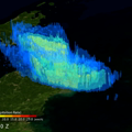
 | | |  |  |
| Date/Time: | Jul 04,2006 04:38 (UTC) |
| Satellite/Sensor: | Aqua/AMSR-E |
| Path Number | 214MA |
| Lat/Lon: | 2.4N-21.8N
122.6E-139.9E |
| DownLoad: | P01B(V04) P2AP0(V04) P2WV0(V04) |
|
GSMaP |
 |  |  |  onClick='toggleDiv(event,this.src,"imageA");' onClick='toggleDiv(event,this.src,"imageA");' | |
|
GSMaP |
 | | |  |  |
| Date/Time: | Jul 04,2006 16:50 (UTC) |
| Satellite/Sensor: | Aqua/AMSR-E |
| Path Number | 109MD |
| Lat/Lon: | 11.0N-30.5N
124.7E-142.9E |
| DownLoad: | P01B(V04) P2AP0(V04) P2WV0(V04) |
|
GSMaP |
 |  |  |  onClick='toggleDiv(event,this.src,"imageA");' onClick='toggleDiv(event,this.src,"imageA");' | |
|
GSMaP |
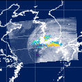
 | | |  |  |
| Date/Time: | Jul 05,2006 17:34 (UTC) |
| Satellite/Sensor: | Aqua/AMSR-E |
| Path Number | 116MD |
| Lat/Lon: | 10.0N-29.5N
113.7E-131.7E |
| DownLoad: | P01B(V04) P2AP0(V04) P2WV0(V04) |
|
GSMaP |
 |  |  |  onClick='toggleDiv(event,this.src,"imageA");' onClick='toggleDiv(event,this.src,"imageA");' | |
|
GSMaP |
 | | |  |  |
| Date/Time: | Jul 06,2006 04:27 (UTC) |
| Satellite/Sensor: | Aqua/AMSR-E |
| Path Number | 212MA |
| Lat/Lon: | 7.9N-27.3N
124.1E-141.8E |
| DownLoad: | P01B(V04) P2AP0(V04) P2WV0(V04) |
|
GSMaP |
 |  |  |  onClick='toggleDiv(event,this.src,"imageA");' onClick='toggleDiv(event,this.src,"imageA");' | |
|
GSMaP |
 |  |  |  onClick='toggleDiv(event,this.src,"imageA");' onClick='toggleDiv(event,this.src,"imageA");' | |
|
GSMaP |
 | | |  |  |
| Date/Time: | Jul 07,2006 05:11 (UTC) |
| Satellite/Sensor: | Aqua/AMSR-E |
| Path Number | 219MA |
| Lat/Lon: | 9.0N-28.4N
112.9E-130.8E |
| DownLoad: | P01B(V04) P2AP0(V04) P2WV0(V04) |
|
GSMaP |
 |  |  |  onClick='toggleDiv(event,this.src,"imageA");' onClick='toggleDiv(event,this.src,"imageA");' | |
|
GSMaP |
 | | |  |  |
| Date/Time: | Jul 07,2006 17:20 (UTC) |
| Satellite/Sensor: | Aqua/AMSR-E |
| Path Number | 114MD |
| Lat/Lon: | 16.3N-35.9N
118.0E-137.0E |
| DownLoad: | P01B(V04) P2AP0(V04) P2WV0(V04) |
|
GSMaP |
 |  |  |  onClick='toggleDiv(event,this.src,"imageA");' onClick='toggleDiv(event,this.src,"imageA");' | |
|
GSMaP |
 |  |  |  onClick='toggleDiv(event,this.src,"imageA");' onClick='toggleDiv(event,this.src,"imageA");' | |
|
GSMaP |
 |  |  |  onClick='toggleDiv(event,this.src,"imageA");' onClick='toggleDiv(event,this.src,"imageA");' | |
|
GSMaP |
 | | |  |  |
| Date/Time: | Jul 09,2006 05:00 (UTC) |
| Satellite/Sensor: | Aqua/AMSR-E |
| Path Number | 217MA |
| Lat/Lon: | 15.3N-34.9N
113.8E-132.7E |
| DownLoad: | P01B(V04) P2AP0(V04) P2WV0(V04) |
|
GSMaP |
 |  |  |  onClick='toggleDiv(event,this.src,"imageA");' onClick='toggleDiv(event,this.src,"imageA");' | |
|
GSMaP |
 | | |  |  |
| Date/Time: | Jul 09,2006 17:06 (UTC) |
| Satellite/Sensor: | Aqua/AMSR-E |
| Path Number | 112MD |
| Lat/Lon: | 23.3N-42.9N
122.4E-142.9E |
| DownLoad: | P01B(V04) P2AP0(V04) P2WV0(V04) |
|
GSMaP |
 |  |  |  onClick='toggleDiv(event,this.src,"imageA");' onClick='toggleDiv(event,this.src,"imageA");' | |
|
GSMaP |
 |  |  |  onClick='toggleDiv(event,this.src,"imageA");' onClick='toggleDiv(event,this.src,"imageA");' | |
|
GSMaP |
 |  |  |  onClick='toggleDiv(event,this.src,"imageA");' onClick='toggleDiv(event,this.src,"imageA");' | |
|
GSMaP |
 | | |  |  |
| Date/Time: | Jul 10,2006 04:08 (UTC) |
| Satellite/Sensor: | Aqua/AMSR-E |
| Path Number | 208MA |
| Lat/Lon: | 26.7N-46.4N
122.8E-144.4E |
| DownLoad: | P01B(V04) P2AP0(V04) P2WV0(V04) |
|
GSMaP |