 May 28, 2003
Green Oases Have Made the Silk Road
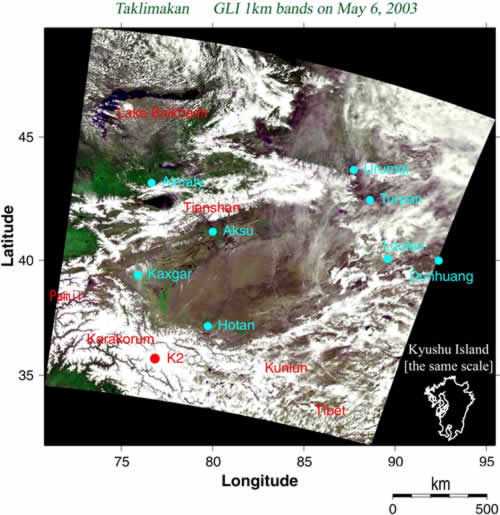
This is an image of northwest China acquired by
GLI on May 6, 2003 with a resolution of 1 km. It was processed so that vegetation looks green and water looks dark purple or black.
The Taklimakan Desert stands at the center of the image surrounded by the Tianshan Mountain Range to the north and the Kunlun Mountain Range to the south. The area of the desert is about 340,000 square kilometers, which corresponds to the area of Japan. The green area at the northwest is the Kazakhstan steppe that ends at the Caspian Sea to the west. The long, slender lake to the north is Lake Balkhash. The mountainous snow-covered area at the southwest reaches more than 4000 meters above sea level; it includes Pamir Plateau, known as "the Roof of the World", and Karakorum Mountain Range, with K2, the second highest mountain in the world (8611 meters high).
The water from thawing snow and ice on the mountain ranges runs below the desert and creates oases where it flows to the surface again. These oases are observed as green vegetation along the mountain ranges in the
GLI image. The oasis cities of Uighur people, such as Kashgar and Khotan, are located where vegetation is conspicuous. The spring snow water even affects the central area of the desert. At the center of the image, we find that the water has moistened the desert with a red color and that the Khotan River again flows with water.
The east-west roads that connect these oases are well known as the Silk Road, over which caravans of camels have delivered goods from surrounding countries, greatly influencing the culture of the various regions. From ancient times, many travelers have passed along these roads. One of the most famous journeys is that of Hsuan Chuang in the early Tang Dynasty (the first half of the 7th century A.D.) who crossed Taklimakan Desert, walked over Gandhara, and reached India in quest of the Buddhist scripture.

At the eastern terminal of the Tarim River, which collects the thawed snow water from the Tianshan Mountain Range and runs through the northern side of the Taklimakan, Lake Lop Nur, known as "The Wandering Lake" after a book of explorer Hedin, was once filled with much water. However, the water from the Tarim River was consumed for large-scale farmland irrigation in the second half of the 20th century, so the lake eventually disappeared completely. Earth-observation satellites are the only way to monitor such large-scale environmental changes. In this sense, the satellites are like the eyes of the universe protecting the greenery of the Earth. Their importance is increasing day-by-day.
Earth Observation Research and application Center, Japan Aerospace Exploration Agency
JAXA EORC
ALL RIGHTS RESERVED.