 May 9, 2003
The Marvels of Nature, Grand Canyon
- Layers of stratum that reflect ancient history -
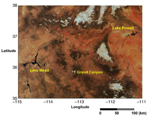
This is an image of the Grand Canyon in Arizona, USA acquired by
GLI on March 21, 2003. The white range of mountains with snow covered tops, and black indicates water such as lakes and rivers.
An area of 5000km2 along the Colorado River, which runs from the Lake Powell in the east side of the image to the Lake Mead in the west, is designated as the Grand Canyon National Park. We can see huge cliff that the Colorado River has been making by eroding the red and brown stratum that is almost equal to the area of Chiba Pref.(5146km2).
The Grand Canyon, the biggest valley in the world, is 450km long (1.5 times as long as the Tone River) and 1.6km deep, and is divided north and south by the Colorado River running at the bottom of the valley.

This precipitous cliff that bowls over the humans took 6 to 10 million years to create. Billions of years earlier, the Colorado Plateau had risen out of the ocean and was subsequently eroded by the Colorado River, fed by ground water and rain. We can now see strata representing almost one-third of the Earth's history, from the old one of 2 billion years ago to the new one of 200 million and 5 thousand years ago. The chronological record on the canyon walls makes this an unique and valuable geological site. The Grand Canyon National Park was added to the UNESCO world heritage list in 1979.
Earth Observation Research and application Center, Japan Aerospace Exploration Agency
JAXA EORC
ALL RIGHTS RESERVED.