 Apr. 2, 2003
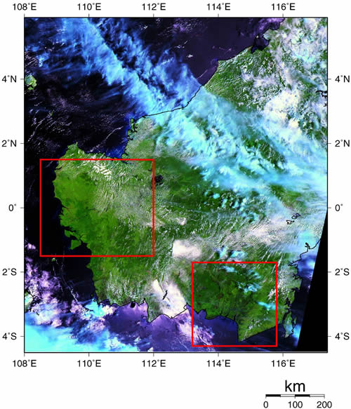
Steaming Kalimantan
The 250 meter
GLI image above was captured on February 21, 2003. The scene covers almost the entire island of Kalimantan, which at 737,000 square kilometers is the largest island in Asia and the third largest in the world. The island is dominated by tropical rainforests and large peat swamps in its interior and mangroves along its coasts. It harbors vast natural resources, such as petroleum, natural gas, timber and gold, as well as a unique and rich ecology. Intersecting the Equator, Kalimantan has a humid climate and weather conditions are thus predominantly cloudy. Cold high-altitude clouds appear blue in the
GLI image, while the warmer lower cloud formations are more uniformly bright across the spectral range. The southern and western parts of the island were relatively clear during the ADEOS-II pass, and the Indonesian coastal towns of Pontianak and Banjarmasin are clearly visible (enlarged).
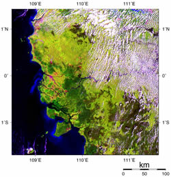
Pontianak is located almost on the Equator, at the mouth of the Kapuas River, which is the longest river in Kalimantan. Yellow and light green areas indicate low vegetation (Tropical Zone plain), such as agricultural lands and grasslands, while non-vegetated areas such as Pontianak itself, appear red, brown or purple. Darker green represents forests and mangroves.
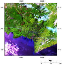
The second enlargement depicts the region around Banjarmasin, the largest town on the island and the state capital of Indonesian Kamimantan. Banjarmasin at the mouth of the Barito River appears brown, and its surroundings are dominated by on-going and abandoned agriculture and secondary succession. Darker green or black colors represent peat swamp forests that are distributed over much of the region. Waterways, which are very prominent in the image, are the primary means of goods transport in this area and a lot of business activity is dependent on them.
The above false color images were composed using the spectral channels 28 (1640 nm), 23 (825 nm) and 22 (660 nm), wavelengths ranging from visible to the short wavelength infrared region.
The
GLI land-science group endeavors to identify the vegetation dynamics and distribution using
GLI 1km and 250m channels; 1km data is for global research and 250m data is for more detailed information.
Earth Observation Research and application Center, Japan Aerospace Exploration Agency
JAXA EORC
ALL RIGHTS RESERVED.

 » See Larger Images