 Mar. 28, 2003
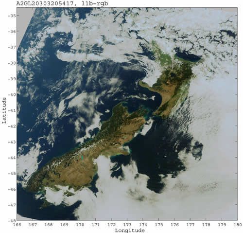
Two islands of New Zealand
This image shows the North Island and the South Island of New Zealand observed by
GLI on 20 March 2003. Snow-capped mountains can be seen in the Southern Alps range called "the Backbone of South Island." Some lakes can be recognized at the foot of the 700-kilometer long range. A blue shinning lake, Lake Pukaki, in the middle of the range and other neighboring blue lakes are glacier lakes created as the glaciers retreated. The water appears "glacier blue" because small particles of rocks crushed by glaciers float in the water and reflect sunlight. Mt. Cook, the highest peak in New Zealand (elevation 3450m), can be seen at the north end of Lake Pukaki. This picturesque landscape composed of glacier lakes and many mountains over 3000m capped with glaciers, is called the "Southern Alps" (Alps in the southern hemisphere).

Fourteen fiords, including Milford Sound, were made as glaciers retreated and surround a 210-kilometer length of the southwest coast of South Island. These coastal areas receive much moisture brought by wet winds (westerlies) from the Tasman Sea west of the island because the winds are blocked by the high mountains. One of the world's largest rainforests of beech trees has thus developed due to the plentiful rains.
Compared to the South Island, North Island has a large population because of its more temperate climate, and most of its has been developed as residentid areas or farms.
This
GLI image contrasts the geographic features of South Island with its rugged ranges and varied nature, and North Island, which is relatively flat.
Earth Observation Research and application Center, Japan Aerospace Exploration Agency
JAXA EORC
ALL RIGHTS RESERVED.