The SeaWinds scatterometer which was developed by NASA's Jet Propulsion
Laboratory (JPL) aboard the Advanced Earth Observing Satellite-II (Midori-II)
has successfully transmitted its first radar data to our home planet, generating
its first high-quality images.
From its orbiting perch high above Earth, SeaWinds on Midori II will provide the
world's most accurate, highest resolution and broadest geographic coverage of
ocean wind speed and direction, sea ice extent and properties of Earth's land
surfaces.
 » See Larger Image (1000×500pixels: 252KB)
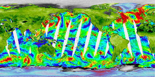
The released image, obtained from data collected on January 28 and 29, depicts Earth's continents in green, polar glacial ice-covered regions in blue-red and sea ice in gray. Color and intensity changes over ice and land are related to ice melting, variations in land surface roughness and vegetation cover. Ocean surface wind speeds, measured during a 12-hour period on January 28, are shown by colors. Blues correspond to low wind speeds and reds to wind speeds up to 15 meters
per second (30 knots). Black arrows denote wind direction. White gaps over the oceans represent unmeasured areas between SeaWinds swaths.