 Jan. 20, 2003
AMSR First-light images: AMSR capturing the Japanese Islands / Sea ice distribution in the Sea of Okhotsk
 AMSR capturing the Japanese Islands
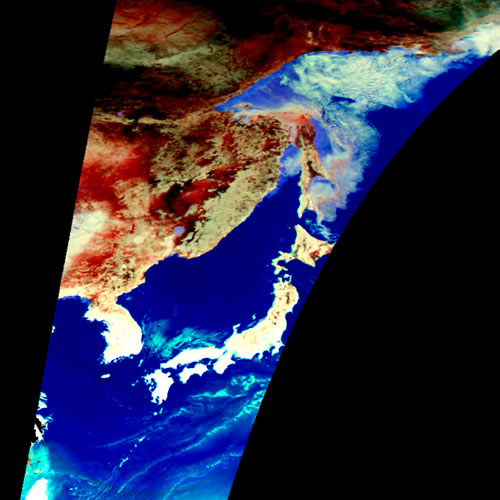
The false-color composite image is from the data obtained by the Advanced Microwave Scanning Radiometer (AMSR) onboard the Midori-II (Advanced Earth Observing Satellite-II: ADEOS-II).
 |
| False-color composite image |
Both AMSR and Midori-II were developed by the National Space Development Agency of Japan (NASDA). Brightness temperatures of 36.5-GHz (horizontal polarization) and 89.0-GHz (both vertical and horizontal polarization) channels were used. The data is acquired around 11 a.m. on January 18, 2003 JST. Over the Pacific Ocean and Japan Sea, the areas of light blue correspond to high-concentration liquid water clouds. In the Sea of Okhotsk, colors varying from light blue to white correspond to sea ice distribution.
- Sea ice distribution in the Sea of Okhotsk observed by AMSR
Sea ice distribution in the Sea of Okhotsk captured by the Advanced Microwave Scanning Radiometer (AMSR) aboard the Midori-II (Advanced Earth Observing Satellite-II: ADEOS-II).Both AMSR and Midori-II were developed by the National Space Development Agency of Japan (NASDA). The left image is a false-color composite using the data acquired at night time (around 20:30) on January 18, 2003 JST. Brightness temperatures of 36.5-GHz (horizontal polarization) and 89.0-GHz (both vertical and horizontal polarization) channels were used. In the Sea of Okhotsk, colors varying from light blue to white correspond to sea ice. Distribution of newly-formed sea ice is approximately indicated by light blue. Areas of light blue over the Pacific Ocean correspond to high-concentration liquid water clouds. It is the advantages of microwave observation techniques to enable measurements during night and day. Thus, through non-precipitating clouds, the sea ice extension can be well distinguished using the night-time image.
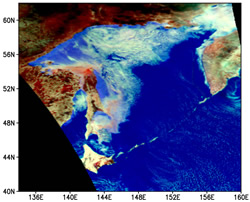 | 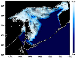 |
| False-color composite image | Sea ice distribution and motion vector |
The right image shows the sea ice concentration estimated from the same data. Cobalt blue indicates open sea surface with no sea ice coverage. Increase of sea-ice covered areas is indicated by colors varying from cobalt blue to white. The arrows superimposed on the map shows sea ice motion derived by comparing AMSR data acquired at 8:30 p.m. and that from the same day about 10 hours before. It can be seen that sea ice is advancing southward from northern part of the Sea of Okhotsk and reaching to the Shiretoko Peninsula. This year, the sea ice is advancing southward faster than in other years. At the Abashiri weather station in Hokkaido, Japan, approaching sea ice was observed on January 11th at the first time.

Earth Observation Research and application Center, Japan Aerospace Exploration Agency
JAXA EORC
ALL RIGHTS RESERVED.